Category: Source codes

  • Multi-View Datasets

    Multi-View Datasets

    AiRound

    AiRound is composed of 11,753 images distributed among 11 classes, including: airport, bridge, church, forest, lake, river, skyscraper, stadium, statue, tower, and urban park.
    Each sample is composed by a triplet, that contains images in 3 distinct points of view: (i) a ground perspective image; (ii) a high resolution RGB aerial image; and (iii) a multi-spectral image taken from the Sentinel-2 satellite.
    All images are paired and were manually checked to guarantee their correctness.

    [siteorigin_widget class=”SiteOrigin_Widget_Image_Widget”][/siteorigin_widget]

    CV-BrCT

    CV-BrCT is composed of 24K pairs of images, each one containing a street-level scene and a high-resolution aerial image. Those samples are labeled in 8 different classes, which includes apartment, hospital, house, industrial, parking lot, religious, school, store, and vacant lot.

    [siteorigin_widget class=”SiteOrigin_Widget_Image_Widget”][/siteorigin_widget]

    Download Dataset/Code

    [siteorigin_widget class=”SiteOrigin_Widget_Button_Widget”][/siteorigin_widget]
    [siteorigin_widget class=”SiteOrigin_Widget_Button_Widget”][/siteorigin_widget]
    [siteorigin_widget class=”SiteOrigin_Widget_Button_Widget”][/siteorigin_widget]
  • Deep Semantic Segmentation of Mammographic Images

    Deep Semantic Segmentation of Mammographic Images

    Deep Semantic Segmentation of Mammographic Images

    MIAS and INbreast are mammographic datasets for the detection and diagnosis of breast cancer. With the dawn of digital mammograms, one important preprocessing step for the tasks of detection and diagnosis is the removal of the pectoral muscle and background area from the images, therefore this task has been tackled by the literature over the last decades. The suplementary material below is a complement to the contents in the paper Deep Semantic Segmentation of Mammographic Images, awaiting acceptance in the 21st International Conference on Medical Image Computing & Computer Assisted Intervention (MICCAI) 2018. This page contains:


    [su_list icon=”icon: circle”]

    • the pretrained Deep Neural Networks (DNNs) used in the paper;
    • the predictions made by the DNNs over the datasets;
    • python source codes with the modified versions of the networks used in the paper;
    • the complete spreadsheets with all the results from the paper; and
    • a python source code for forwarding mammograms through the pretrained models.

    [/su_list]

    [su_accordion]
    [su_spoiler title=”Pretrained models”]
    The 1,311 scenes, which have <strong>of 64 x 64 pixels</strong>, are partitioned into 4 classes: Agriculture, Arboreal, Herbaceous and Shrubby Vegetation. The identification of each vegetation (i.e. ground-truth annotation) was perfoategories: rmed manually by biologists and specialists. The dataset has:


    Type Instances
    Agriculture 47
    Arboreal Vegetation 962
    Herbaceous Vegetation 191
    Shrubby Vegetation 111

    Download

    [/su_spoiler]

    [/su_accordion]

    [su_accordion]
    [su_spoiler title=”Segmentation predictions”]
    The 1,311 scenes, which have <strong>of 64 x 64 pixels</strong>, are partitioned into 4 classes: Agriculture, Arboreal, Herbaceous and Shrubby Vegetation. The identification of each vegetation (i.e. ground-truth annotation) was performed manually by biologists and specialists. The dataset has:

    Type Instances
    Agriculture 47
    Arboreal Vegetation 962
    Herbaceous Vegetation 191
    Shrubby Vegetation 111

    Download
    [/su_spoiler]

    [/su_accordion]

    [su_accordion]
    [su_spoiler title=”Python code for the modified DNN models”]
    The 1,311 scenes, which have <strong>of 64 x 64 pixels</strong>, are partitioned into 4 classes: Agriculture, Arboreal, Herbaceous and Shrubby Vegetation. The identification of each vegetation (i.e. ground-truth annotation) was performed manually by biologists and specialists. The dataset has:

    Type Instances
    Agriculture 47
    Arboreal Vegetation 962
    Herbaceous Vegetation 191
    Shrubby Vegetation 111

    Download
    [/su_spoiler]

    [/su_accordion]
    [su_accordion]
    [su_spoiler title=”Complete set of results”]
    The 1,311 scenes, which have <strong>of 64 x 64 pixels</strong>, are partitioned into 4 classes: Agriculture, Arboreal, Herbaceous and Shrubby Vegetation. The identification of each vegetation (i.e. ground-truth annotation) was performed manually by biologists and specialists. The dataset has:

    Type Instances
    Agriculture 47
    Arboreal Vegetation 962
    Herbaceous Vegetation 191
    Shrubby Vegetation 111

    Download
    [/su_spoiler]

    [/su_accordion]

    [su_accordion]
    [su_spoiler title=”Python code for testing in your own datasets”]
    The 1,311 scenes, which have <strong>of 64 x 64 pixels</strong>, are partitioned into 4 classes: Agriculture, Arboreal, Herbaceous and Shrubby Vegetation. The identification of each vegetation (i.e. ground-truth annotation) was performed manually by biologists and specialists. The dataset has:

    Type Instances
    Agriculture 47
    Arboreal Vegetation 962
    Herbaceous Vegetation 191
    Shrubby Vegetation 111

    Download
    [/su_spoiler]

    [/su_accordion]

    [siteorigin_widget class=”Recent_Posts_Widget_With_Thumbnails”][/siteorigin_widget]
  • Contextual descriptors for superpixel-based segmentation

    Contextual descriptors for superpixel-based segmentation

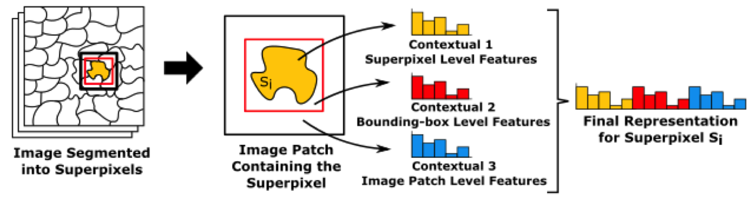
    Land-cover maps are one of the main sources of information for studies that support the creation of public policies in areas like urban planning and environmental monitoring. Their automatic creation involves learning to annotate all samples of a Remote Sensing Image (RSI) from just a few annotated by the user. Nevertheless, low-level descriptors like color and shape are not enough to produce a discriminative representation for the samples that represent objects that share similar visual appearance. In order to overcome this limitation, three methods to encode the context of the samples extracted from regions are proposed in this work: the first combines low-level representations from adjacent samples, the second one counts co-occurrences of visual words over a local area and the last one exploits ConvNets to compute deep contextual features. Confirming previous studies, the generated maps were improved by incorporating context in the representations used to feed the classifier.


    Source code


    Some relevant work in this topic are:

    [su_spacer]

    T. Santana, K. Nogueira, A. M. C. Machado, J. A. dos Santos. Deep Contextual Description of Superpixels for Aerial Urban Scenes Classification. In: International Geoscience & Remote Sensing Symposium (IGARSS 2017), 2017, Fort Worth
    T. Santana, A. M. C. Machado, A. A. Araújo., J. A. dos Santos. Star: A Contextual Description of Superpixels for Remote Sensing Image Classification. In: CIARP 2016 – XXI Iberoamerican Congress on Pattern Recognition, 2016, Lima.

    Support contact: Tiago Moreira <tiagohubner10@gmail.com>

    [siteorigin_widget class=”Recent_Posts_Widget_With_Thumbnails”][/siteorigin_widget]
  • Natural disaster monitoring

    Natural disaster monitoring

    Natural disaster monitoring is a fundamental task to create prevention strategies, as well as to help authorities to act in the control of damages, coordinate rescues, and help victims.
    Among all natural disasters, flooding is possibly the most extensive and devastating one being considered as the world’s most costly type of natural hazard in terms of both economic losses and human causalities.
    Although extremely important, floods are difficult to monitor, because they are highly dependent on several local conditions, such as precipitation, drainage network, and land cover.
    A first and essential step towards such monitoring is based on identifying areas most vulnerable to flooding, helping authorities to focus on such regions while monitoring inundations.
    In this work, we tackled such task using distinct strategies all based on ConvNets.
    Specifically, we proposed novel ConvNet architectures specialized in identifying flooding areas as well as a new strategy focuses on exploiting network diversity of these ConvNets for inundation identification.
    This work was considered the winner of the Flood-Detection in Satellite Images, a subtask of 2017 Multimedia Satellite Task, which was part of the traditional MediaEval Benchmark.


    Code available here: https://github.com/keillernogueira/FDSI

    [siteorigin_widget class=”Recent_Posts_Widget_With_Thumbnails”][/siteorigin_widget]
  • Multiscale classification of remote sensing images

    Multiscale classification of remote sensing images

    A huge effort has been applied in image classification to create high-quality thematic maps and to establish precise inventories about land cover use. The peculiarities of remote sensing images (RSIs) combined with the traditional image classification challenges made RSI classification a hard task. Our aim is to propose a kind of boost-classifier adapted to multiscale segmentation. We use the paradigm of boosting, whose principle is to combine weak classifiers to build an efficient global one. Each weak classifier is trained for one level of the segmentation and one region descriptor. We have proposed and tested weak classifiers based on linear support vector machines (SVM) and region distances provided by descriptors. The experiments were performed on a large image of coffee plantations. We have shown in this paper that our approach based on boosting can detect the scale and set of features best suited to a particular training set. We have also shown that hierarchical multiscale analysis is able to reduce training time and to produce a stronger classifier. We compare the proposed methods with a baseline based on SVM with radial basis function kernel. The results show that the proposed methods outperform the baseline.


    Source code


    Related papers:

    [su_spacer]

    J. A. dos Santos, P-H. Gosselin, S. Phillip-Foliguet, R. da S. Torres, A. X. Falcão. Multiscale Classification of Remote Sensing Images. IEEE Transactions on Geoscience and Remote Sensing, v. 50, p. 3764-3775, 2012
    J. A. dos Santos, P-H. Gosselin, S. Phillip-Foliguet, R. da S. Torres, and A. X. Falcão. Interactive Multiscale Classification of High-Resolution Remote Sensing Images. IEEE Journal of Selected Topics on Earth Observations and Remote Sensing, v. 6, p. 2020-2034, 2013
    J.A. dos Santos, F.A. Faria, R. Torres, A. Rocha, P.H. Gosselin, S. Philipp-Foliguet, A.X. Falcao Descriptor Correlation Analysis for Remote Sensing Image Multi-Scale Classification. In International Conference on Pattern Recognition, Tsukuba Science City, Japan, November 2012
    Almeida, J. A. dos Santos, B. Alberton, R. da S. Torres, and L. P. C. Morellato. Applying Machine Learning based on Multiscale Classifiers to Detect Remote Phenology Patterns in Cerrado Savanna Trees. Ecological Informatics, 2014.
    [siteorigin_widget class=”Recent_Posts_Widget_With_Thumbnails”][/siteorigin_widget]